Bay Shore Route Break Down
In my latest Microsoft Flight Simulator 2024 video, I navigated the Baron B58TC through the complex San Francisco airspace via the Bay Shore route. I breezed through the flight plan in the video because it would have taken all the time to explain the different airspaces. The nice thing about a blog post is that it does have all the time, so if you’re a flight simmer who’s curious what the route was and how to read the airspaces, this is for you.
I know I shouldn’t need to say this, but if you’re a real pilot looking for a primer on flying the real life Bay Shore route, this post isn’t for you. This flight plan was created to showcase the recent City Update 13 photogrammetry improvements in Microsoft Flight Simulator 2024.
NOT FOR REAL LIFE FLIGHT INSTRUCTION. FOR SIMULATOR USE ONLY
The flight plan:
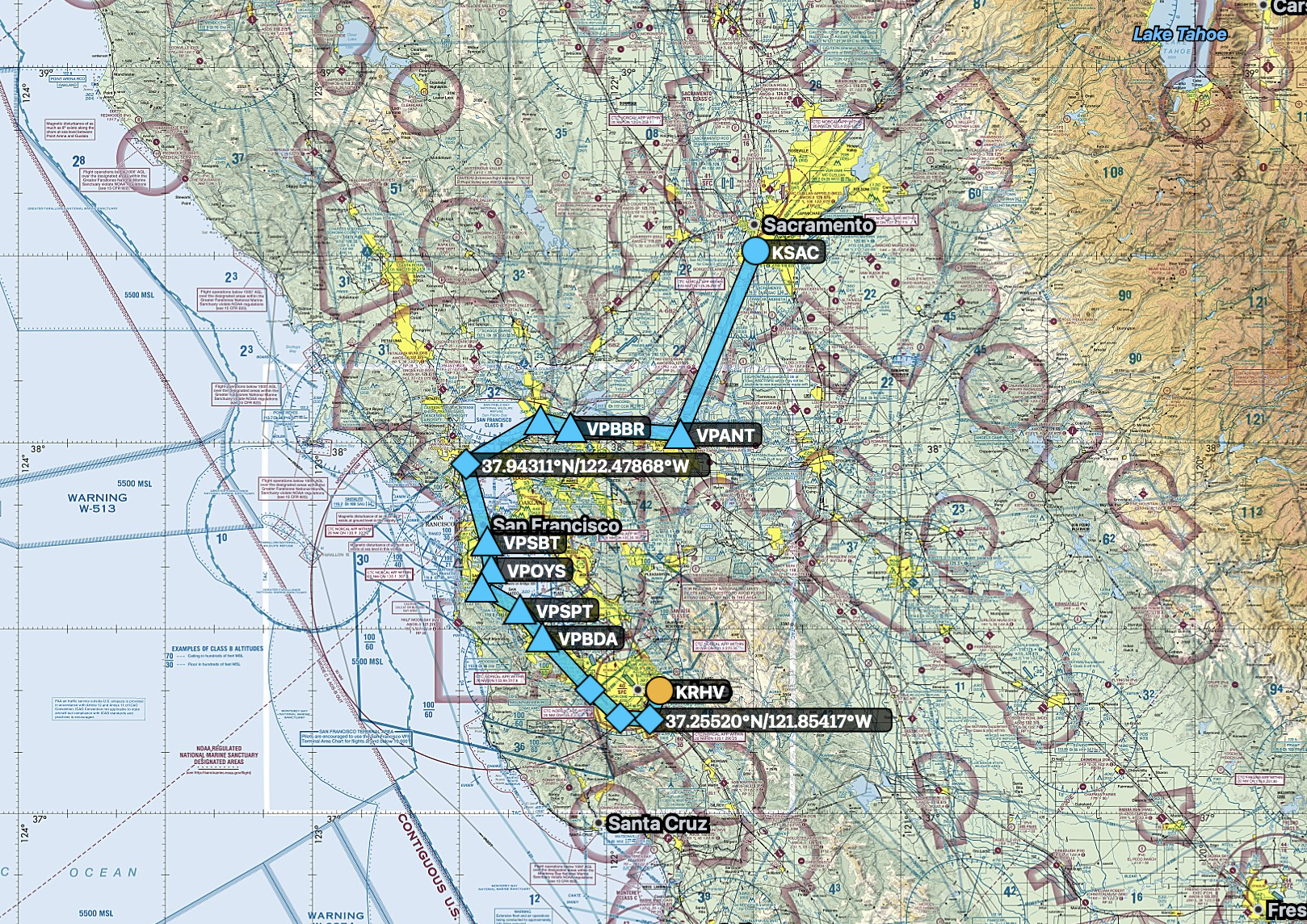
You can see we could just fly direct from KRHV to KSAC and avoid everything, but we’d miss out on the great views
A few primers:
Class D airspace is shown by a dashed blue line. The airspace starts at the ground and extends up to the blue number indicated in the bracketed box, in hundreds of feet
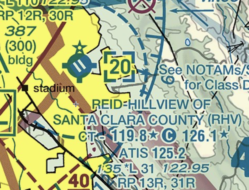
Our departing field, RHV Reid-Hillview, is in Class D airspace indicated by the dashed blue semi-circle. The 20 in the blue box brackets indicates the airspace extends from the surface to 2,000 feet
Class C airspace is shown by a solid magenta line. It usually has an inner and an outer ring, and the outer ring may be subdivided into segments. Each segment or ring has its own beginning and ending altitude, indicated by a magenta fraction. The fraction is the starting altitude and ending altitude in hundreds of feet represented by the bottom and the top number.
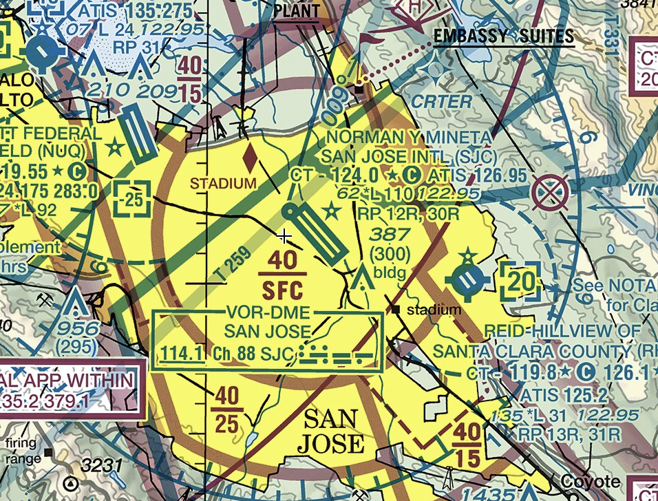
San Jose’s Class C airspace has an inner tower ring (40/SFC) which indicates it starts at the surface and goes up to 4,000 feet. The outer Approach ring has several segments, each having their own starting and ending altitude, such as 40/15 to indicate start at 1,500 feet and end at 4,000 feet
Class B airspace is shown in solid blue lines. Like Class C, it has an inner tower surface area and multiple Approach segments that list their starting and ending altitudes as a blue fraction. Unlike the other airspaces, you explicitly need a clearance to enter Class B airspace.
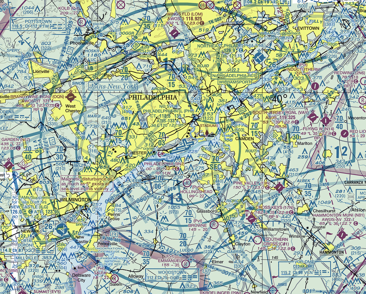
Here I’ve used Philadelphia’s Class B as an example because it’s easier to read. It’s a series of rings, each broken into segments, with each segment having its own blue fraction listed.
Class E airspace, or “everywhere airspace”, is what most of the sky is made of, usually starting at 1,200 feet above ground and extending up to 18,000 above sea level. Think of it as the airspace between airports. Some people call it uncontrolled airspace, but that’s not true. What they really mean is that you don’t need to talk to ATC when flying VFR in it. It’s still controlled airspace, meaning ATC is available for things like IFR flight or flight following.
The only true uncontrolled airspace is Class G, where ATC is not available, usually because it’s too low for radar or it’s in an extremely remote area. In general (with a few exceptions), neither Class E nor Class G are drawn on sectionals. Instead, pilots know that (unless otherwise specified), Class G covers the first 1,200 feet of altitude, then Class E takes over and covers the rest up to 18,000 MSL. Once you get above 18,000 MSL, you’re in the realm of IFR only in Class A.
Fun Trivia: Class A ends at 60,000 MSL and then reverts back to Class E. If you could somehow get this high, you technically wouldn’t need to talk to ATC anymore.
KRHV Reid-Hillview is in Class D airspace that goes from the surface to 2,000 feet. It’s next to KSJC San Jose’s Class C airspace, which is shown with a solid magenta line. We want to depart KRHV and fly through the KSJC southern segments. The first segment starts at 1,500 feet and extends to 4,000 feet. Because of that, we’ll fly at 1,000 feet until ATC gives us permission to enter it. Once they do, we’ll climb to 2,500 feet.
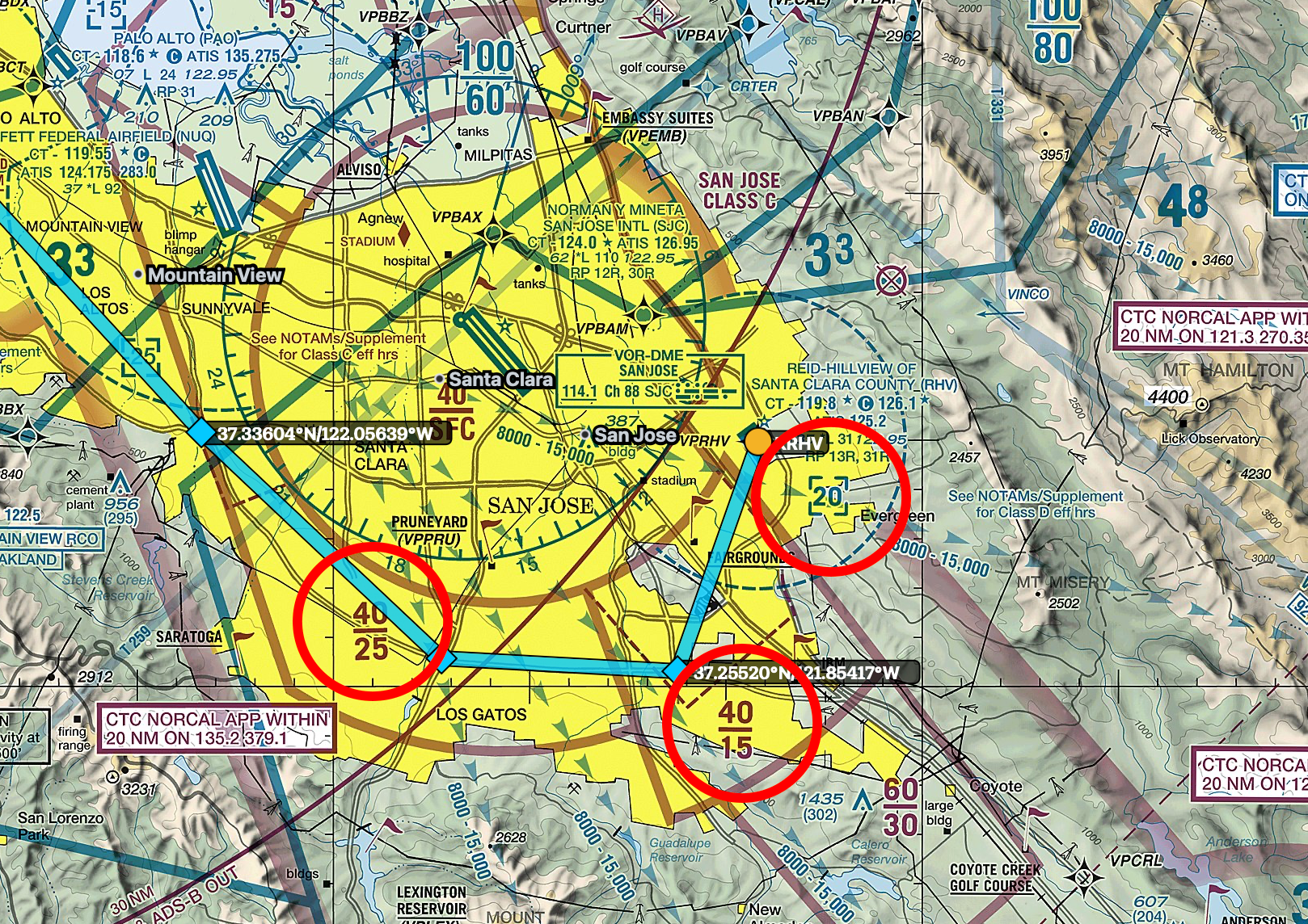
Solid magenta lines indicate KSJC San Jose’s Class C airspace. The dotted blue circle indicates KRHV’s Class D airspace. The fractions are top/bottom of airspace shelves in 100s, such as 40/25 = top of airspace at 4,000 feet and bottom at 2,500 feet.
Because we’re flying VFR, I’ve picked things I can easily see for waypoints, such as major road intersections. You can see the roads drawn on the sectional, above.
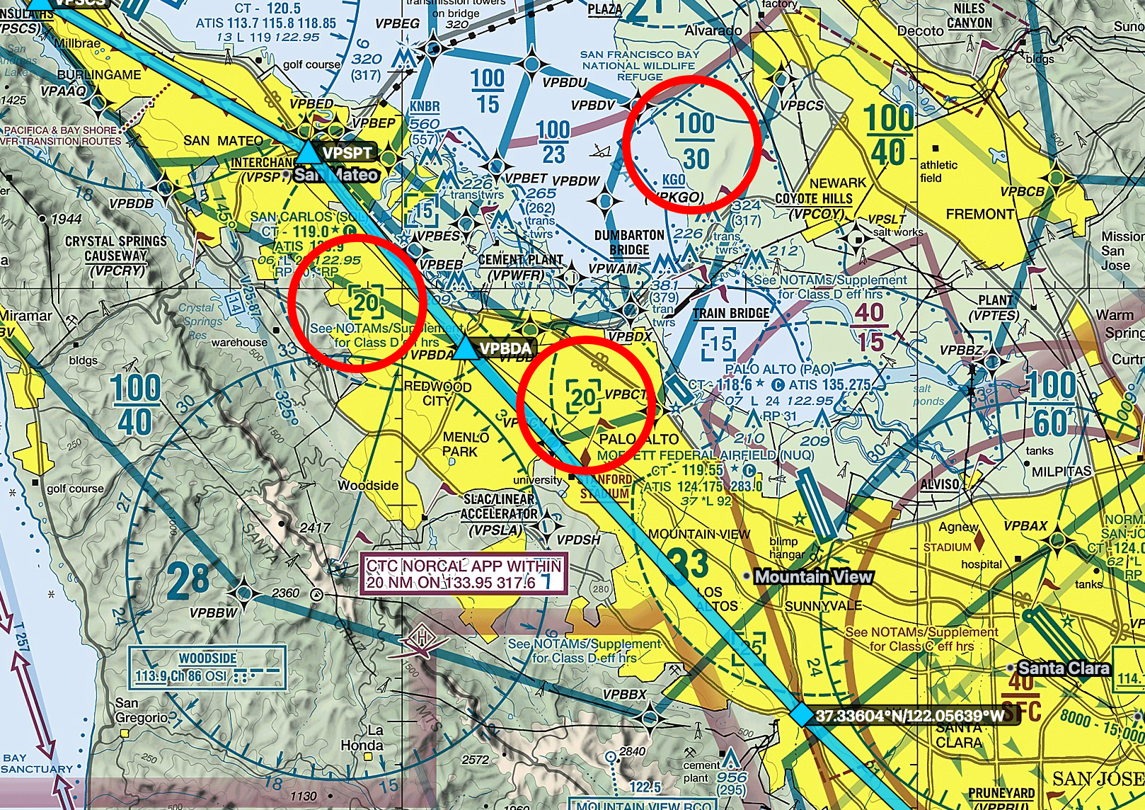
To the north of San Jose, the flight path passes under one of the solid blue lines indicating a KSFO Class Bravo shelf. The shelf numbers are the blue 100/60 north of KSJC, indicating the Bravo starts at 6,000 and goes up to 10,000 feet. We’re okay to fly under it at 2,500 feet and don’t need any special permissions.
We’ll also pass over KNUQ Mofffet’s Class D airspace. It’s hard to see in the screenshot below, but their airspace is listed as “-25” in a blue bracket, which means it extends from surface up to but not including 2,500 feet. So we’re just barely above it flying at 2,500 feet.
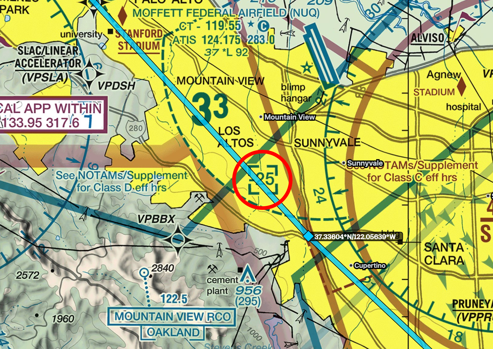
The bold blue 33 under Mountain View looks like a Bravo airspace altitude, but it’s something different. It’s the MEF (Maximum Elevation Figure) that lists the highest terrain or obstacle (in hundreds of feet) in this sectional tile. To clear the tallest thing in the tile, you must fly at least 3,300 feet. Note we’re flying at 2,500, which we can do but must be careful to review the terrain and obstruction elevations along our flight path.
We’ll continue northwest, overflying Stanford Stadium and heading to Highway 101. We’ll overfly Palo Alto and San Carlos Class Deltas, both extending from surface to 2,000 feet. Since we’re at 2,500, we don’t need to talk to them. The Bravo shelf we are under at this point starts at 3,000 feet, so we are still not in Bravo. Before reaching San Mateo, which is the start of the surface area of the Bravo, we will have requested a Bravo transition via Bay Shore Route and we need explicit clearance to enter the Bravo to proceed beyond San Mateo.
What to do if ATC says no? We’ll turn due west over the mountains and follow the western shore remaining clear of the Bravo. We’ll miss out on the KSFO flyby, but still get to see the Golden Gate Bridge and Saulsalito.
When ATC clears us for the Bay Shore transition, we’ll follow the red arrows marked on the VFR sectional. ATC will assign our altitude, and we’re expecting anywhere from 1,500 feet to 2,500 feet. We’ve chosen to stay at 2,500 feet in anticipation of the restriction. In the video, Say Intentions ATC gave me at or below 3,500, so I chose to remain at 2,500.
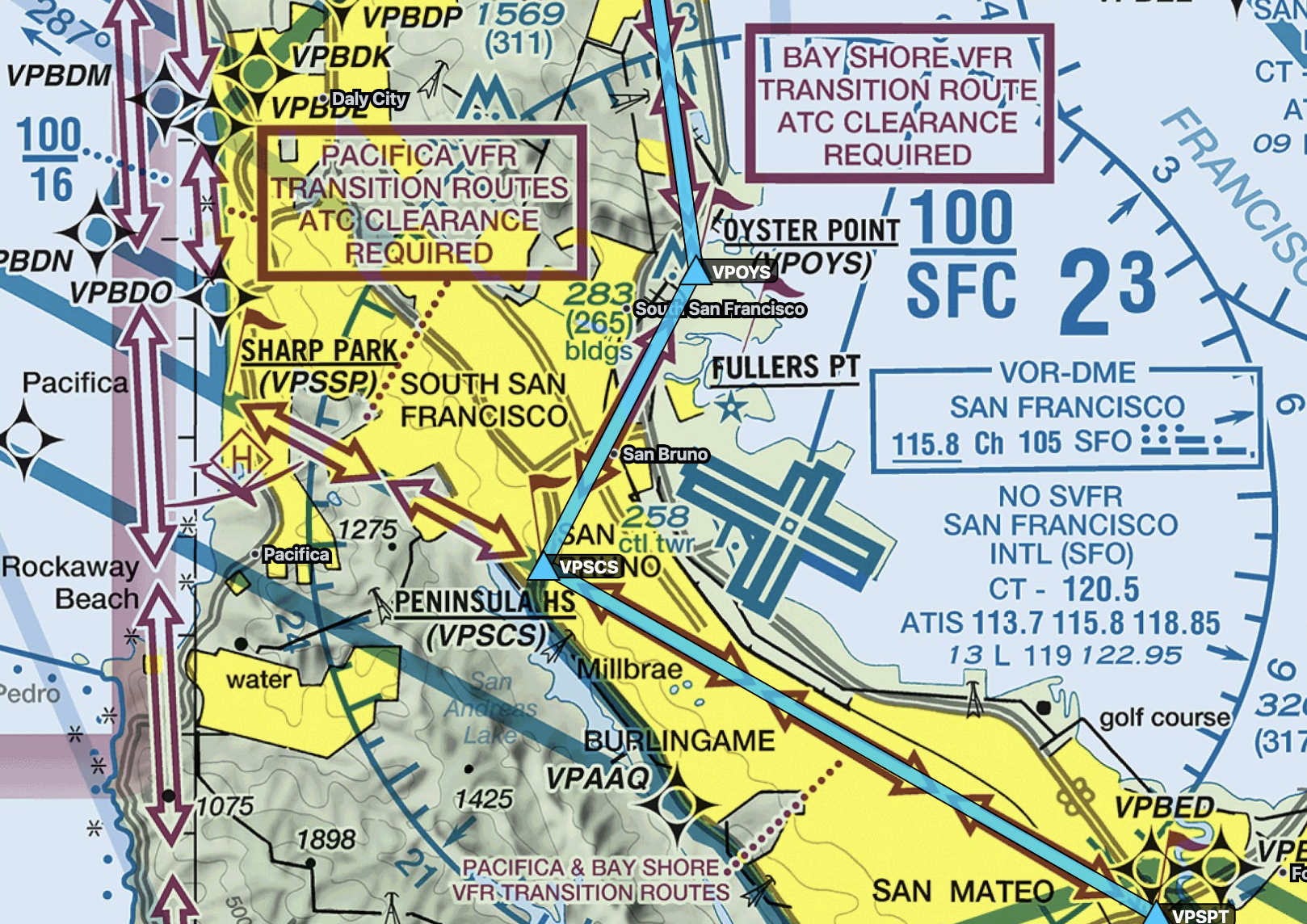
The red arrows are VFR Transition Routes. The red boxed texts indicates that you need ATC clearance to fly them. This isn’t always true. There are other Class Bravos in the US that have VFR transitions that do not require ATC clearance. It’s important to read the text and any insets.
On the north side of KSFO, the Bay Shore Route concludes at Farmer’s Market. The Bravo shelf here is 2,100, increasing to 3,000 as we head north. Although it appears that we’re in the Oakland Class Charlie airspace based on the magenta T/15, this indicates the bottom of Oakland starts at 1,500 feet and ends at the start of the KSFO Class Bravo, wherever that may be. It’s written like that because there are two Bravo shelves overlaying this one Charlie segment, and each Bravo shelf has a different starting altitude.. It is worth noting that with us flying at 2,500, there is a short span after Farmer’s Market where the first 2,100 foot Bravo shelf ends and becomes the second 3,000 foot Bravo shelf. At that point, with us flying at 2,500 feet we have exited the Bravo and we are in the Oakland Charlie airspace that starts at 1,500 feet. Both Oakland and San Francisco use NORCAL Approach, so I’d guess the Approach controller would give me instructions, since they are the controlling authority.
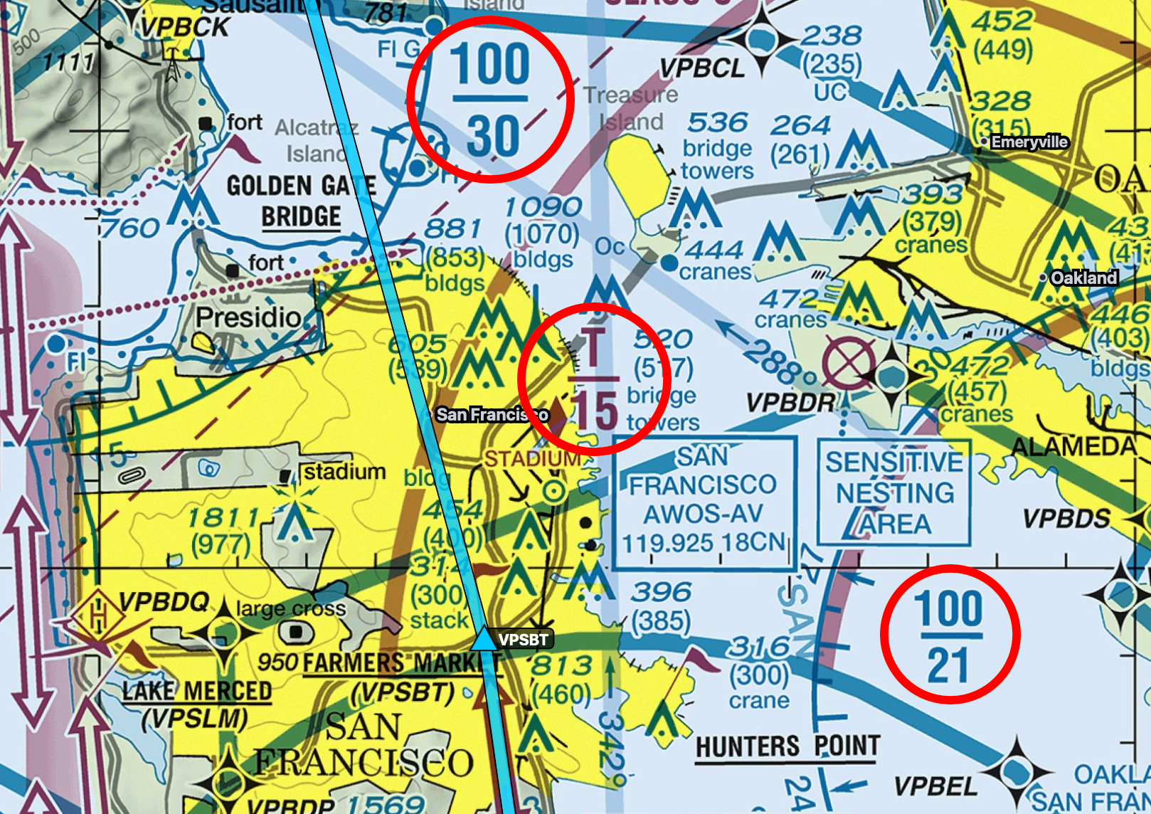
Complicated
As we make our way abeam the Golden Gate Bridge, we’ll exit Oakland’s Class C airspace while still under the Bravo airspace that starts at 3,000 feet. Note we’re flying at 2,500 feet, which means we aren’t in anyone’s airspace anymore and are in good ole’ Class E (“everywhere”) airspace. As such, we don’t need to talk with ATC anymore, if we don’t want to, but we’ll stick with flight following because it’s helpful in busy airspaces.
Things are getting easier. We’ll turn east at the San Rafael bridge, and here the Class Bravo starts at 5000 feet and goes up to 10,000 feet. Flying low is nice for scenery but not terribly safe if we have a problem, so I’d like to get some altitude, so we’ll climb to 3,500 feet. I’ve picked this altitude because we are flying VFR east and need to fly an odd altitude plus 500 feet.
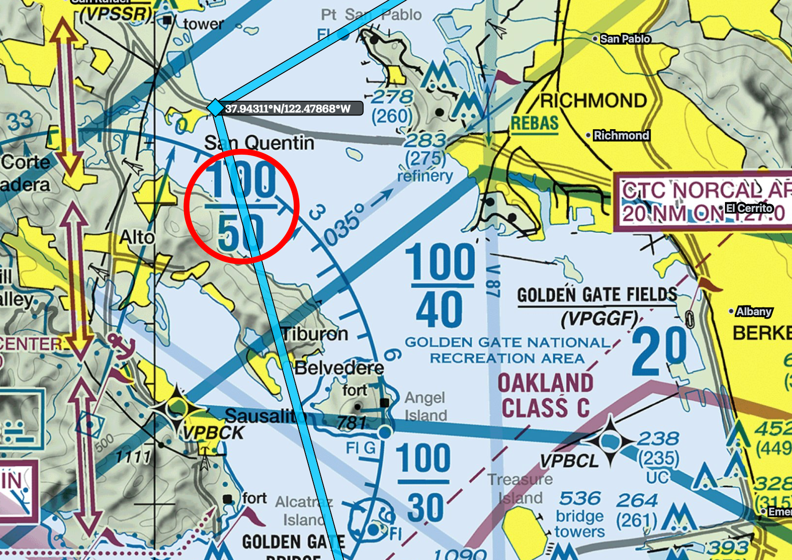
Flying under the last Bravo shelf
As we approach the Carquinez Bridge, the Bravo ends and we’re free to climb to 5,500 feet, which will give us a little more of an altitude if we have any problems. There’s a bunch of other airspace symbols as we approach this area, including a red hashed polygon with big red letters and numbers:
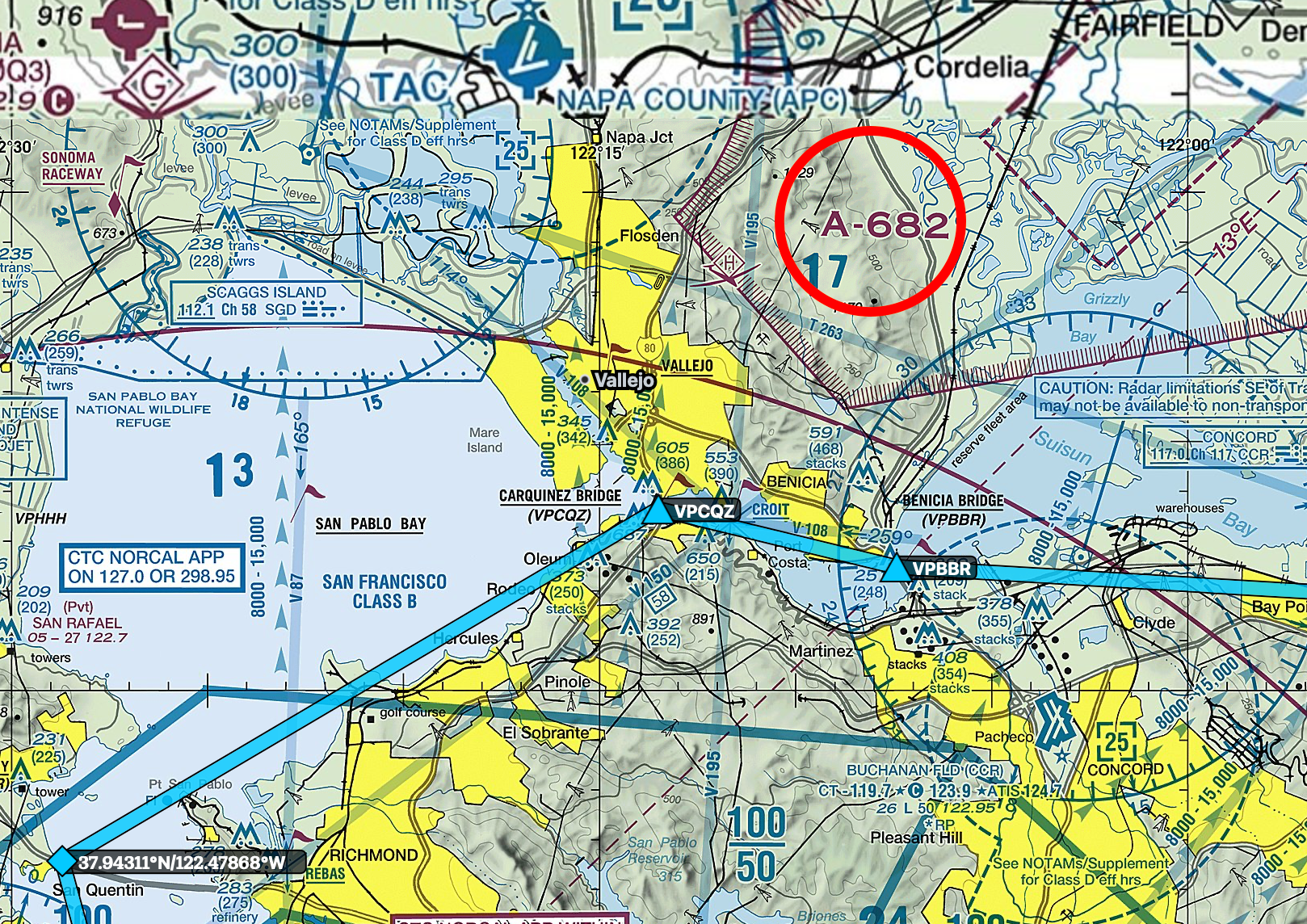
The hashed red polygon labeled A-682 is an Alert Area for Travis Air Force Base. We are free to fly in it without permission, but we should be, well, alert. It’s a warning that something like a high volume of flight training may be happening.
Now, we’ll just follow the bay bridges until the Antioch bridge, where we’ll follow the Sacramento River. This will be our cue to get the weather for KSAC San Francisco Executive, because Exec Tower will ask us for the ATIS code when we request landing. KSAC itself is a Class D, just south of the Class C of Sacramento and west of the Class D of Mather. From an awareness standpoint, if we end up on the north side of KSAC we’ll need to mind the 41/16 Class C shelf, which shouldn’t be a problem if we’re at traffic pattern altitude of 1,000 feet.
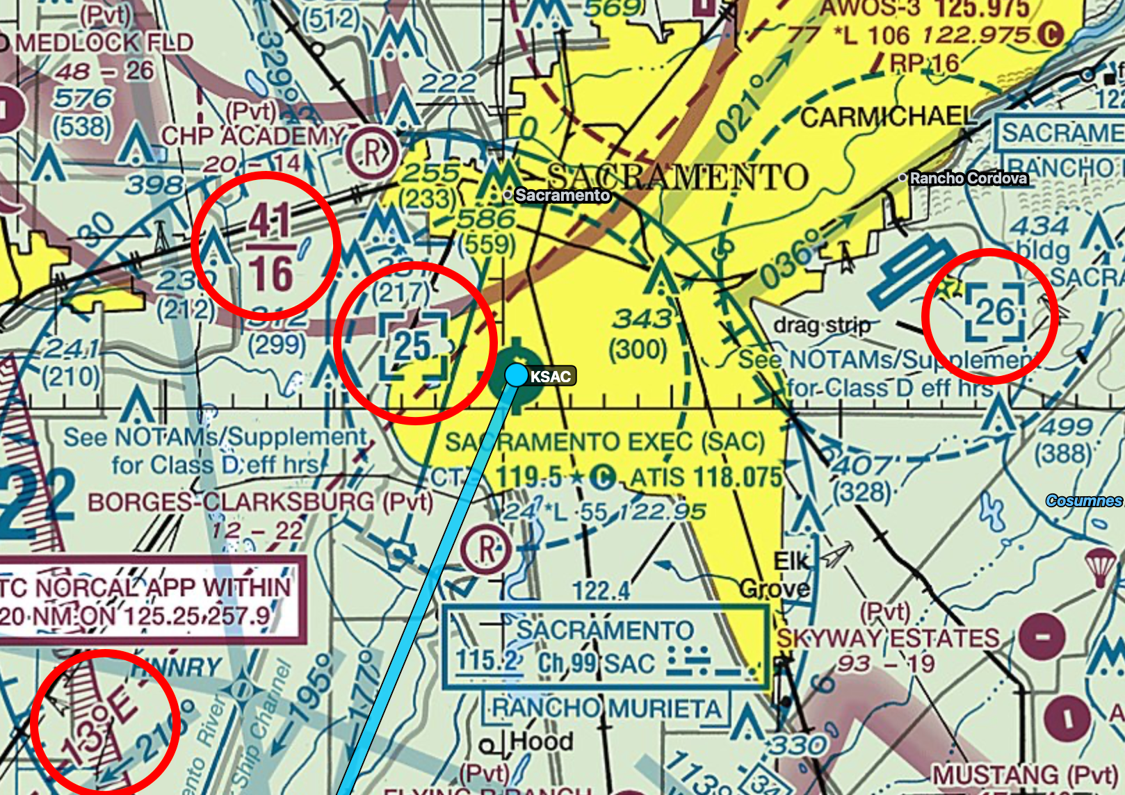
Bonus topic! See that 13 degrees E in the lower left? You probably know that if you hold a compass, it doesn’t point to the Earth’s North Pole, but instead points to magnetic north. This changes based on where you are on the planet because the Earth’s magnetic field is not uniform. The map is telling you that at this spot on the planet, magnetic north is 13 degrees east of true north . If you know how to read the VOR compass rose, it’s easy to see that the north arrow on the compass rose is tilted to the right of the North-South longitude line that passes through KSAC. VORs use magnetic north while sectional maps use true north.
One other bit of trivia is that magnetic north changes over time. Runway numbers, for example, use the magnetic heading of the runway when the runway was created. So runway 24 aligns with 240 magnetic degrees. Over time, magnetic north changes, for example runway 24 might now align with 250 magnetic degrees. Because of this, sometimes an airport will re-number the runway to fix the offset. VORs are the same. Magnetic north on a VOR might be different than what magnetic north is now because time has elapsed since it was created. If you were to look up Sacramento’s VOR, SAC, listed on the sectional above, its magnetic north is 17 degrees east of true north. This is off by 4 degrees versus what is listed on the sectional for magnetic north as 13 degrees E. Confusing, huh? When I first started flight simming and plotting out courses in SkyVector, I could never understand why the numbers didn’t match up, or why up and down on the map wasn’t north and south on my compass.
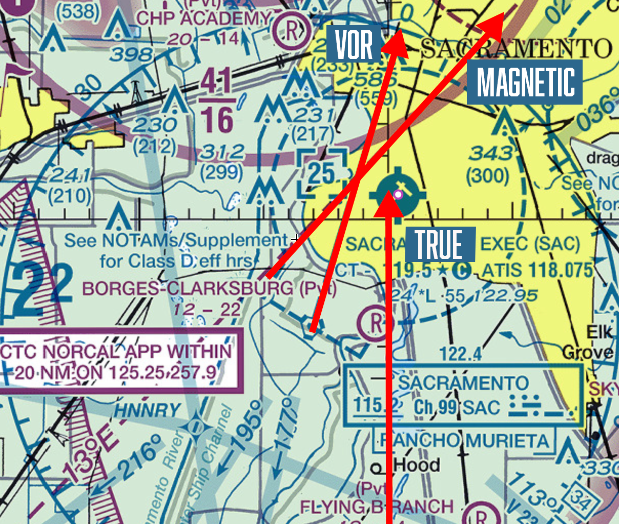
Three different Norths
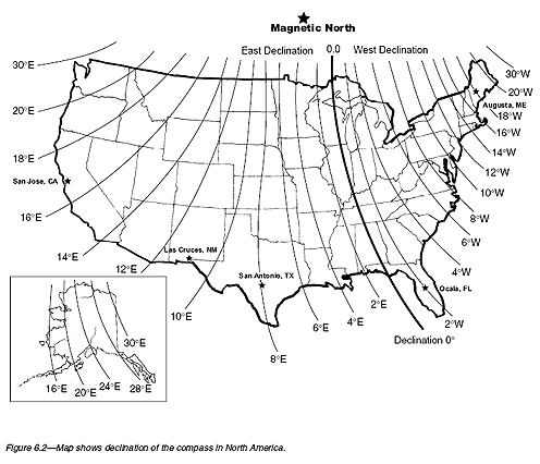
United States magnetic declination diagram. Your compass will point along the line, wherever you are located in the US